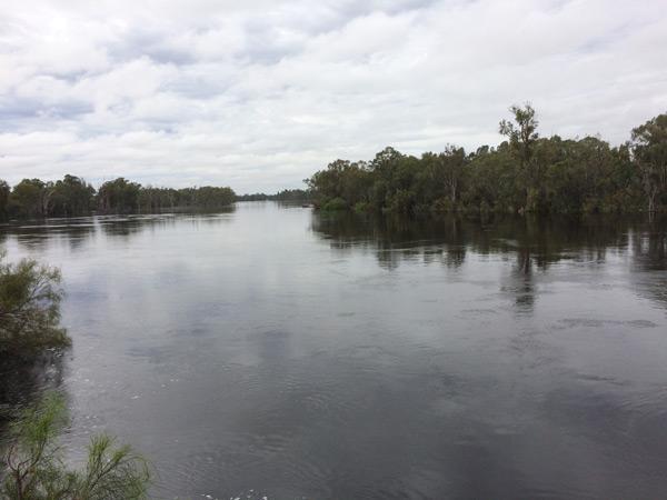
Picture above credit: Andy Wise
The end of 2016 saw one of the worst Blackwater events unfold in the Murray Darling Basin. Throughout winter, New South Wales and Victoria were smashed by huge amounts of rain week after week. This rainfall continued well into spring and parts of the country saw major flooding.
The Murray, Murrumbidgee, Lachlan and Macquarie Rivers went into flood causing damage to buildings, crops, roads and property. The Newell Highway was cut off for weeks between Parkes and Forbes due to the intense rainfall and flooding. These areas hadn’t seen a flood like this for over 40 years.
‘As the flooding progressed through spring, the temperature began to rise and a catastrophe was building – hypoxic Blackwater.’
Unfortunately we watched massive amounts of large Murray Cod, Golden perch, crayfish and shrimp perish due to the Blackwater that passed over thousands of kilometres of river floodplains in the west of NSW, VIC and then through SA. The amount of carbon picked up by the floods was huge, given the lack of large floods in recent decades over vast areas of land. Coupled with warming temperatures through spring, the water in the flood became hypoxic and wiped out much of the native population.

Massive floods along the Murrumbidgee River in the city of Wagga Wagga. Credit: photo by Grant Higginson
What Happened?
As the water inundates the flood plain, it picks up carbon in the form of plant matter (leaves, grass and bark), animal faeces and other debris. Floodwater picks up these carbon sources when it floods any dry floodplain – including forests and cleared floodplain like farmland. As these massive inputs of carbon decompose and leach into the water turning it black in colour – thus the name. Decomposition of this material by microbes also, sucks the dissolved oxygen from the water making it hypoxic (low in dissolved oxygen), and potentially deadly to anything that needs to breathe under the water. More and more floodplain carbon is picked up as the flood front moves along the river.
Learn more about Blackwater… click here
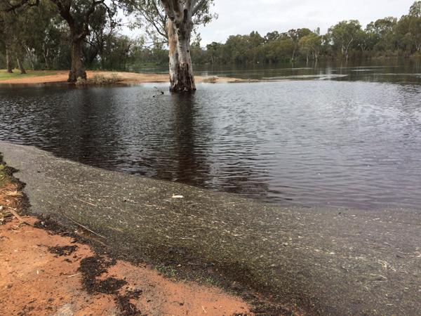
Here is an example of hypoxic Blackwater from the recent floods - you can tell by the dark tea like colour
Why did this happen?
Many questions were raised during the fish kill and people are after answers as to why this has happened. Why has it never happened before? And why wasn’t the 2010 or 2012 flood this bad?
I spent some time researching and interviewing experts in the field of Blackwater and the effects on the fish. To help answer the question we need to go over a bit of history:
History of Water Flow and Floods
Historically river regulation was all done via the sky… rainfall, without any interruption by humans. Since then we have impacted on how the system works and have turned it upside down. With the construction of weirs, dams, channels, irrigation and locks, we now hold back, capture and regulate the water flow.
This process is a part of any civilisation as water is the most sought after and precious resource. It is needed for irrigation of crops and farm land which is a huge economic activity for Australia.
‘Controlling the rivers is great for humans but it has a negative effect on the marine environment, in this case our native fish species.’
By controlling the water flow there are fewer flooding events which are vital for healthy rivers and their fish populations. First of all, fish need flooding to help with breeding, travelling and growth. Second and most importantly in this case, frequent flooding events helps avoid massive blackwater events like we have just experienced.
Historically the rivers in the southern Murray Darling Basin used to break their banks and inundate the floodplain every 2-4 years – these were considered small to moderate floods. Nowadays, we regulate the flow in most of our rivers and try to stop small and moderate sized floods from happening, and its only larger events like the one just experienced, that actually inundate floodplain. This regulation stops properties, roads, bridges and farmland from being inundated and gives us some security in water supply for towns and farming. The problem is the river needs to flood every few years to wash the organic matter from the flood plain – without flooding this material builds up for many years and even decades.
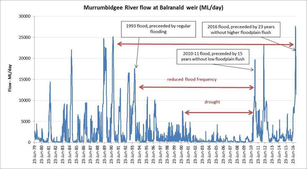
Graph showing history of water flow heights on the Murrumbidgee River at Balranald. You can see the 2016 flood covered flood plains that haven't been covered since 1993 - data courtesy MDBA
Analysing the graphs:
These two graphs show the yearly water flows along a specific section of the Murrumbidgee and Murray Rivers. A high peak on the graph represents high water flows (usually floods) and over the years you can see how the flows have been altered. We have changed the natural flow of water and you can see during the period of drought there wasn’t a single flood. With the impoundments almost being bone dry and little water around we had to hold onto as much as we could for irrigation, this allowed the organic matter to build up on the flood plain. The longer this organic matter built up without being inundated, the worse and more intense a Blackwater event would be during the next flood.
The 2010 flood washed a lot of organic matter away but you can see the higher parts of the flood plain on both the Murrumbidgee and Murray Rivers still hadn’t been ‘burnt off’ (cleaned by a flood). The next big flood was a disaster waiting to happen… and this is what happened in the 2016 flood.
If you look before 1992 the river would have a large flood every couple of years and this is naturally what happened. This meant the organic matter built up was at most 5 years’ worth and wouldn’t cause intense and disastrous Blackwater events.
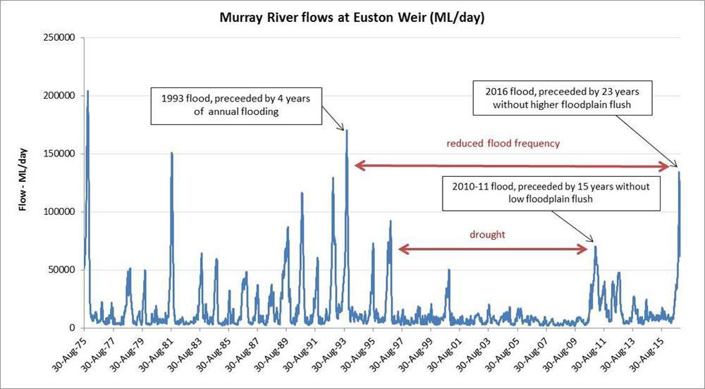
Graph showing history of water flow heights on the Murray River at Euston. You can see the 2016 flood covered flood plains that haven't been covered since 1993 - data courtesy MDBA
The floods throughout 2010-12 were smaller than this one, but because they came at the end of the drought, they inundated big areas of lower lying floodplain that hadn’t been wet for 10-15 years, and hence killed many fish when accumulated debris started to breakdown. The 2012 floods were also patchy, with some areas being more effected than others. The Edward/Wakool region was hit particularly hard by Blackwater along with other regions.
The 2016 floods were larger, with water spreading further out on to the floodplains to some areas which hadn’t been underwater for over 30 years. There wasn’t enough space in dams and storages to capture all the rain that fell through winter and spring and the rivers burst. Because this type of uncontrollable flood hadn’t really occurred across many river since the 1990’s there was so much material to breakdown that the water again turned hypoxic and caused huge fish kills.
There was nothing that could be done to stop the Blackwater event from happening.
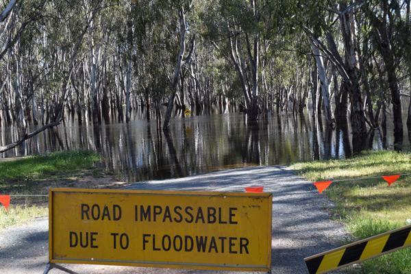
The Murrumbidgee River near Balranald covering ground that hadn't been underwater for over 23 years. Credit: photo by Adam Smith
Areas Affected
The Murray River was hit extremely hard by the Blackwater and it’s hard to tell but some locations may have lost most of their large cod, which could have been up to 50 years in age. While stretches of the Murray River channel upstream of Barmah Forest and between Echuca and Tooleybuc escaped with few losses, other areas experienced massive loses:
- The large floodplain region including the Barmah-Millewa and the Koondrook-Perricoota Forests experienced massive fish kills.
- The Edward-Wakool River system also suffered badly with large areas of farmland on the floodplain inundated for the first time in decades.
- The Murrumbidgee River went very black with fish kills detected in the area below Balranald, and so far there are no reports of big numbers of dead fish. Environmental flows behind the flood helped reduce the duration of the hypoxic event, and minimised the damage.
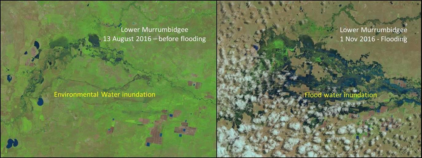
Satellite images showing the difference between environmental water compared to the floods during spring. You can see the massive inundation by the start of November along the lower section of the Murrumbidgee River.
- Unfortunately the Murray River downstream of the Edward and Murrumbidgee Rivers encountered significant blackwater hypoxia as carbon flushed from these catchments washed into the larger river. Dead fish, generally larger cod (which like larger people require more oxygen) were noted along the river, with larger kills of smaller native fish identified in backwater areas or billabongs in which fish may have become trapped (e.g. the Mildura Marina).
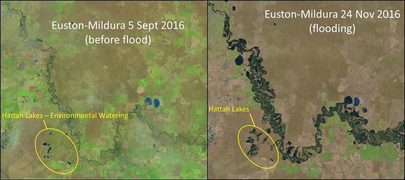
Satellite images showing the difference before and after the flooding. This image is extremely powerful and shows the huge extent of the flooding that took place along the Murray River. This flood inundated a massive amount of land. You can also see on the left image where environmental water was used to fill Hattah Lakes, which is nothing compared to the inundation caused by the floods. Image credit: Landsat, USGS Global Visualization Viewer
- Hundreds of large Murray Cod were killed in the Rufus River which exits Lake Victoria. It is likely many of these fish had moved from the Murray River into the Rufus seeking refuge in the better water leaving Lake Victoria as the floodwaters began to rise. Unfortunately the blackwater ultimately made its way through the Frenchmans Creek and the Lake itself into the top of the Rufus River – essentially sandwiching these fish in hypoxic blackwater as temperatures soared through November.

Satellite images showing one of the worst flooded areas which occurred on the Rufus River. This area was hit extremely hard by Blackwater and masses of large Murray Cod perished due to Blackwater coming from the Murray River and Lake Victoria. These images show just how much water spread out across the flood plains. Image credit: Landsat, USGS Global Visualization Viewer
- Except for the lower stretch influenced by the Murray, the Darling River was saved due its floodwaters gathering lower levels of carbon. A small in channel flow was released to the Lower Darling (downstream of the Menindee Lakes) through spring 2016 to increase habitat for Murray cod who responded with record spawning detected by researchers. This water also provided a small cue for suffering fish in the Murray to move in to the Darling at Wentworth and take refuge. Increasing the release rate from Menindee might have provided some dilution of the blackwater in the Murray River during the fish kills, but couldn’t occur due to concerns it would increase flooding of property at Wentworth.
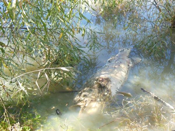
Massive numbers of cod perished on the Rufus River as they were trapped between two walls of Blackwater - this event was catastrophic for the cod population
Where to Now?
This event has happened and is now in the past, nothing can be done about it BUT something needs to be done for the future. We need to learn from what’s happened and try to reduce the severity of Blackwater in the future, or even better stop it from happening altogether.
‘Throughout the floods many people asked the question about environmental water. Was it to blame for the massive Blackwater event?’
Environmental water didn’t cause the problem and in fact it’s actually a way in which we can reduce this happening into the future. If we can use environmental flows and better river management to create small floods and clean up at least the lower lying flood plain, we would see less severe Blackwater events in the future when big uncontrolled floods do occur.
Want to learn more about Environmental Water… click here
A big issue at the moment is the maximum allowed water level when creating an artificial flood with environmental water. These are called ‘constraints’ in the Murray Darling Basin Plan – these are impacts which would occur on things like road access, low lying bridges and people’s property (e.g. houses or farmland) that would happen if the artificial flood went higher than a certain level. Whilst most of these are also affected in natural uncontrolled floods, if they were flooded during an environmental water event, they could be considered “third party” impacts, and not natural events.
The current maximum “within constraints” water level in most regions isn’t high enough to effectively flush large areas of the floodplain, including lower lying billabongs and lagoons. To lift this level (or “relax” some constraints) we can do things like re-build higher bridges, or move access roads or creek crossings. If we are able to do this in some areas, the constrained flood height can be lifted and therefore environmental water could be used to flush more flood plains more regularly (as happened historically).
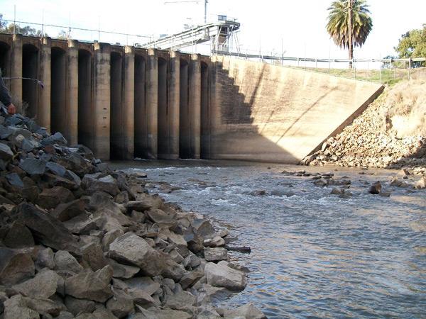
There is obviously now a dramatic fish population decline and we need to help these populations bounce back! Improved river regulation and flow can help promote fish breeding, survival and travel. Matching river flows to fish needs is key to help bring fish populations back in highly affected areas, and our understanding of native fish needs is far better today than it was just ten years ago. Both Golden Perch and Murray Cod will travel thousands of kilometres to spawn or to repopulate affected areas, so getting the appropriate flows in the right rivers at the right time will help with this travel, and also with success of breeding. This brings us to the next issue of fish passage. Many weirs, lock and dams will also stop fish travelling to affected areas so working on building fish ladders is something that needs to be addressed.
And finally did you know that water pumps and water extraction channels in the river can suck up huge amounts of eggs and small fish? These fish may not die, but in most cases they can never make it back to the river system. This is an issue that can be easily fixed by applying a specialised screen over the end of pumps in the rivers and creeks. This will in turn keep more fish in the waterway and help to build stronger populations.
Learn more about the specialised screens here:
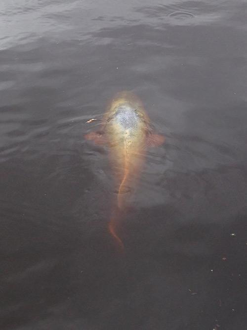
A large Murray Cod struggling to survive in Blackwater on the Murray River in lock 10. It breaks anglers hearts to see something like this happen... Credit: photo by Nigel Harris
Transparent Information is Key
The issue with the whole picture; Blackwater, river flows, environmental water, fish populations and the recreational fishery is the lack in communication. I had to search and search for the information you have just read.
‘Water management, fisheries and governing bodies need to be more transparent with information as to what is happening and why!’
As a recreational angler we too need to have our say on what happens. We are the people who spend majority of the time on the water and use these waterways for recreation. For many of us the rivers are our livelihood and our backyard.
From a fishing point of view variation in water flow and environmental water makes it hard to catch fish, while it’s in flow. I agree these water flows are needed for the fish population but it makes it hard for us to fish. Is there a point in which we can all meet to benefit the fish population, the ecosystem, the irrigators and famers and also the anglers?
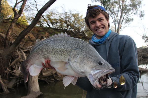
Communication between everyone who cares about our natives species is the way forward! Transparent information is key!
The solution is better communication. How good would it be if as a recreational angler you could access a calendar that shows all the planned releases and heights along the river? Or a website or app you could use to find this information? Or maybe even receive information via text or email? This way you could plan your fishing trip in advance knowing that you won’t get washed out by a rising river.
As previously mentioned, DPI Fisheries has invited me to play a role in how to improve communication between us – the caretakers of our sport – and water management agencies. In my view we are all engaged anglers! For a long time we have wanted to know more about why, where and when water releases will occur and how that impacts on improved fish outcomes. So as a member of the newly created Engaged Fishers Advisory Committee in the Murray-Darling Basin, I have provided numerous ideas on how engagement with anglers and the various departments can be improved. Those recommendations are now being considered and I’m confident we will see increased engagement, better access to information about planned releases and overall, improved communication.
The destruction of the Blackwater that swept through the lower reaches of the Murrumbidgee River. These fish were found perished near Balranald. Credit: photo by Adam Smith
In Summary
Blackwater events will always happen in floods but they shouldn’t always cause hypoxia and fish kills. There are things that we can do to help reduce their severity. This 2016 event was unstoppable and was expected to happen when a big flood finally hit, with some floodplains holding over 40 years of built up organic matter. The way of human life has altered the river ecosystem but we need to find solutions to help it recover. Whether that be; regularly flooding the flood plain with controlled watering events, helping fish stocks to breed and travel around, fish stocking programs, habitat and riparian zone restoration, minimising impacts of cold water pollution, education of proper fishing techniques, promotion of catch and release fishing. These may take time but most importantly we need to build better links of communication – something we can all pursue as engaged anglers!
If you have any ideas, thoughts or comments please either comment below (if you are logged in to the website), comment on the Facebook post or send us an email at [email protected]
“For the future of the sport and the species”
Rhys Creed
More Resources
Video presented by Iain Ellis from Fisheries explaining the flooded satellite images:

0 comments